Showing posts with label History. Show all posts

Monday, March 5, 2012

Welcome to the Wild West - Part #4: Roads and Rails

The Colorado Mountains presented a huge obstacle to transportation throughout Colorado and this was one of the reasons the gold rush didn't start any earlier. But as placer gold deteriorated and more complicated extraction processes were needed, and as Colorado began experiencing its companion silver mining boom, not only were roads necessary, but railroads also became critical to making mining economically viable. They were also necessary to opening up the territory to settlement and development.

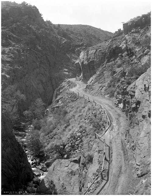
Rail and Trail down Ute Pass. Source.
TRAILS:

Trails were first set down by the native Indians but these were nothing more than tracks. As Colorado developed, real roads needed to be constructed to get in and out of the mining camps. Can you imagine how difficult it would've have been to build these roads on the sheer sides of mountains or through deep canyons? But before railroads were built, these were the only means of access and they became very busy indeed despite the tolls lumped on them by private owners. See, since there was a lack of strong communities in the west, or provisions to pressure the government, private road building was a free-for-all.

Mears' Million Dollar Highway. Source.
One of these private road-builders was Russian-born immigrant Otto Mears, who built some 300-450 miles of toll roads in and around the San Juan Mountains in south-western Colorado. With a keen vision, he built his roads in conformations and at grades suitable for railways and subsequently many of his routes were purchased by railway companies moving into the area.

His most enduring legacy is a 25 mile (40km) section of road of what is now US 550 running from Ouray to Silverton. Built in the 1880s, it was cut directly into the side of steep mountains, however, the 12 mile section that spurred the road’s nick-name as The Million Dollar Highway starts just south of Ouray through the Uncompahgre gorge to the summit of Red Mountain Pass.

And not much has changed on that section since, except that it is now paved. Drivers still must negotiate the nail splitting, hair-pulling, narrow twists, turns, and switchbacks running along clear, steep drop-offs. Chase and I travelled this section of road in 2008. Going south we were stuck on the cliff-edge side and even with the snow banks providing a faux guard-rail (since there are none), it was still scary as hell!

There are several legends to why it was called the Million Dollar highway, though nobody knows for sure. One was that it cost a million dollars a mile to build in the 1920s, another that its fill dirt contains a million dollars in gold ore.

1880s                                          (Source)
2000s                                                                          (My photo)

In addition to wagon roads, Mears built railroads and eventually owned four separate lines around the Silverton area.

Ute Pass is another road of historical importance in Colorado, lying west of Colorado Springs in central Colorado. It skirts the north side of Pikes Peak through the Fountain Creek canyon, climbing 3,000 feet to its summit in the settlement of Divide at 9,165 feet, and remains one of only a handful of access points into the Rocky Mountains along Colorado's Front Range.

Having its beginnings as a Native American trail used by the Ute Indians it became the most popular wagon route to the gold-fields by the 1860s. It was also one of the few roads in the mountains that wasn’t a toll road. But it was only a one lane trail and those coming by stagecoach or hauling goods by oxen and cart had to work out a plan so they wouldn't run into each other. It was also steep on the east side, with a 7% gradient. As you can see below, wooden railings were built to keep the animals from falling off the side!

Ute Pass Wagon Train. (Source).
Ute Pass 1890. (Source).

In 1872, to lessen the danger as more traffic headed to the mountains, a new route was built over Ute Pass using Fountain Creek as a guide. It would be widened several times before becoming US highway 24, one of the originals in this new nationwide system.

After the turn of the century, the state started rebuilding and organising roads in response to public pressure and the advent of the automobile, though improvements were scattered and mountain roads were the last to be touched. The city of Denver undertook an aggressive program of building mountain touring roads, including the highest road in the US up Mount Evans (which I hope to go up once the road is reopened after winter) in response to a toll road that was built to the summit of Pike’s Peak in 1917. Convict labour was used extensively to build roads in Colorado beginning in 1905 and the state led the country in its use until abolishing it in 1926.

RAILS:
Denver & Rio Grande Railway. Source
At the time of the Colorado gold explosion, railroads were being built everywhere in America from the east to the west coast. Competition was strong to build the first transcontinental railroad (TC) and while the Union Pacific got the rights, Denver and Colorado were left out of the plans with the line cutting north of the state through the gentler hills of Wyoming, avoiding the Rockies altogether. It was completed on May 10 1869.

Colorado Central narrow gauge train in Clear Creek Canyon
Source
Still, there were a number of Denver businessmen that competed with plans to build their own branch lines north to tie in with the TC line, for without such a vital life-line, the young city of Denver would quickly fall off the map. It didn't take long, and the Denver Pacific Railroad, backed by many prominent local investors, had linked Denver with the TC line at Cheyenne, WY in 1870. It had beaten the Colorado Central Railroad out of nearby Golden to be the first, and with the completion of the Kansas Pacific line to Denver (completed at Strasburg on the Colorado Eastern Plains), the Denver Pacific became integral to the first transcontinental rail link between the east and west coasts of America, and Denver’s future as the State’s Capital was sealed.

Railroad fever took off in Colorado after that, and companies began to spring up in abundance.

The set-back of the Colorado Central (CC)Railroad to build its line north to the TC didn't deter the company's ambitions. First it built a line to link up to Denver before building the first rail lines up to the valuable mining communities west of Golden: Black Hawk, Central City and Idaho Springs. With the help of engineeer Edward Berthoud, they founded a route through Clear Creek Canyon reaching about 50 miles from Denver at its farthest extent. It was short compared to other lines and traversed no spectacular mountain passes, yet it was the prototype for rail lines into Colorado's mountains and of tapping the wealth that lay within them. 
Union Station in Denver Circa 1880. Source
Early railroads all ran on standard gauge track, but Colorado's steep terrain required a narrower gauge railroad. Enter the single-gauge, narrower dimension railroad. The new Denver & Rio Grande Railroad (D&RG), founded by a former director of the Denver Pacific, was the first to introduce these into operation in Colorado which allowed its steam trains and their cars to better negotiate the narrow curving canyons and steep grades in these mountains. With this the D&RG succeeded in connecting central and southern Colorado's high altitude mining towns with Denver, and hence markets back east.

The D&RG was the epitome of mountain
railroading, with a motto of "Through
the Rockies, not around them" and
later "Main line through the Rockies".
At its height, around 1890, the D&RG (now D&RG Western) had the largest operating narrow gauge railroad network in North America and was operating the highest main-line rail line in the US, traversing the Continental Divide at 10,240 ft (3,120m) north of Leadville over Tennessee Pass.

Colorado Springs, Pueblo, Durango, Salida and Gunnison were all towns that began because of the line. Two of its major legacies are the Durango to Silverton line, which was blasted out of sheer cliffs above the Animas River, and the Royal Gorge route, which cut a line through the bottom of one of the deepest canyons in Colorado with the Arkansas River just a few feet from the tracks on one side, and 1,250 foot sheer granite canyon walls on the other. Needless to say, the scenery was spectacular.

One more line of note was the Colorado Midland Railroad, the first standard gauge railroad built over the Continental Divide, running from Colorado Springs to Leadville over Ute Pass, and through the divide to Glenwood Springs and Grand Junction. It was meant to be a serious competitor to the Rio Grande in conquering the Great Divide and constructing the first transcontinental standard gauge railroad through Colorado but due to several problems it only succeeded in becoming a close second and eventually failed.

The Colorado Midland, who's motto was "Throught the mountains, not around"
Source.
Most of Colorado's mountain railroads didn't have a hope to succeed, and the plethora of Colorado Front-Range railroads was as much a competition among cities as among train lines. Too many trains travelled to too many places with no chance of recovering their costs. In fact, as new "hot" mining camps replaced old, dead ones, tracks wandered around the mountains unfinished, searching for a destination. Inevitably, smaller lines fell off the radar or were bought out by the bigger companies after the silver crash and the depression. In fact, none of these Colorado rail companies exist today.

What became of these Railroads?
·       The CC, through a series of reorganizations and acquisitions, eventually became part of the Colorado and Southern (CS) Railway. Its historic mountain lines were dismantled by the mid 20th century but its connecting lines on the Colorado Eastern Plains survive as active lines of BNSF (Burlington Northern & Sante Fe) Railway, a major freight company (of which the CS Railway Company also ended up);
·       The D&RG railroad company is now defunct. Today, most former D&RG main lines are owned and operated by the Union Pacific Railroad;
·       By the 1880s, the Denver Pacific Railroad also merged with the Kansas Pacific and Union Pacific Railroads, with the resulting company retaining the Union Pacific name.
·       The Colorado Midland Railway ceased operations in 1918. Segments of the railroad were then sold to the Midland Terminal Railway; the rest of the line, mostly west of the Midland Terminal connection at Divide, was abandoned. The line was scrapped in the early 1920s.
·       The Union Pacific Railroad remains the largest rail network in the US.

Since the 1990s, 13 railroads, and many scenic historic byways, through some of the most dramatic and beautiful scenery in Colorado, have been revived throughout the Rockies to take modern day tourists on a ride back in time, and reviving some ghost towns in the process.


Above photos from The Colorado Directory

Friday, January 20, 2012

Welcome to the Wild West - Pt 3: There's gold in them thar hills

It took until 1851 for the first permanent settlement of non-Indian origin to be founded in Colorado, at a place called Conejos in the San Luis Valley in south central Colorado, though it was inhabited by a group of Hispanic families. But by the time Colorado became a territory of the United States in 1861 the population came to 25,371. By the time it became a state of the Union its population had sprung to more than 100,000!

What stimulated this population explosion was the fact that there was gold in them thar hills, and what became of it was the biggest gold rush in American history.

Famous picture of a prospector panning for gold.
Source
 Pikes Peak or Bust:

Approximately a decade after the famous gold rush in California, the rush began in Colorado. Gold was first discovered in Colorado in 1858 but it was a false start, producing nothing significant. It wasn't until 1859 that the first major strike was had by George Jackson in a creek in a canyon of the Rockies Front Range at what is now called Idaho Springs, just outside of present day Denver. Then another, more substantial find was subsequently made in a stream not far north from here in a place that came to be called Central City. The rush was now on.

These new strikes brought renewed belief in the existence of gold riches in these mountains. People that had moved on came back while new prospectors came in thousands and the days of the Wild West legend were now about to make their mark.

The first decade of the boom was largely concentrated in this region and within a year some $18 million in gold was extracted. Pikes Peak, the mountain from the Zebulon Pike discovery became famous as a landmark for gold-seekers which guided them to the area much like the bright star guided the wise men to Jesus. The term "Pikes peak or bust" became the motto of gold seekers.
It is estimated that more than 200,000 wagons rolled across the prairies of Kansas and Nebraska in 1859 and 1860, many of them carrying a sign with the now famous phrase “Pikes Peak or Bust.” [1]

Pike's Peak Miners. Wikipedia.org
The influx of these fortune-seekers provided the first major white population in the region which helped create many early towns as well as the formation of Colorado Territory itelf. More gold brought more boom towns, but these early shanty towns were bawdy, rough places dominated by the hardiest of men. Tent stores, and log saloons sprang up along the muddy streets of raw new towns, as well as gambling parlours, and brothels for entertainment (scenes from the old movie Paint Your Wagon come to mind).
Central City boomed quickly; by 1860, it had a population of 60,000 people and was at the centre of what became known as "The Richest Square Mile on Earth". However placer deposits were quickly exhausted and replaced by corporate underground mining operations, but these operations kept the town prospering for some time and for a while it rivalled Denver, an up-and-coming city, itself.
Many colourful personalities of Colorado lived there, including Horace and Baby Doe Tabor, Doc Holliday (more on these people below), and "Unsinkable" Molly Brown. The Opera House attracted international performers like the Barnum & Bailey Circus, Oscar Wilde, Buffalo Bill, and Harry Houdini. [2]

Miners drinking in a Colorado saloon, 19th Century. Source
Denver grew almost overnight, not from any gold discoveries but from it's strategic location at the juncture of the south Platte River and Cherry Creek, which fashioned it into major supply centre. It all started when a man picked a track on the east side of Cherry Creek, and marked its centre with cottonwood sticks on November 22, 1858; this was how claims were made on a piece of land, indicating the start of a building. It's economy grew by servicing local miners with gambling, saloons, livestock and goods trading. It's where people started and ended their journey into the mountains, and where they came for respite and gamblers, prostitutes and saloonkeepers took up residence here in order to "mine" the miners.

Colorado's lively camp scenes were described by Horace Greeley of the New York Tribune. He travelled the region and wrote of the frenzy he saw in the 1859 goldfields. Of the fledgling "log city" of 150 dwellings at Cherry Creek/Denver he mused that there were "more brawls, more fights, more pistol shots with criminal intent" than any place of comparable size. (Insight guide: Colorado).

Other towns sprang up with gold finds, these included Golden, Gold Hill, Fairplay, Colorado City and Boulder. But of all the mining camps in Colorado, the towns of Creede, Tin Cup, and Leadville were the most wild and unruly.

Creede, late 1800s. Source
Creede: For a brief few years Creede was one of the most notorious of the Colorado mining settlements. Initially built in the narrow confines of East Willow Creek Canyon, a tributary of the Rio Grande river in the south-west of the state, the town eventually spilled out of the gulf into the broad plain west of town when almost overnight, the new town grew to 10,000 residents.

A miner named Nicholas Creede discovered a high-grade silver vein here. He supposedly exclaimed "Holy Moses!" and the Holy Moses mine was created and became one of the most profitable holdings in the region. Hastily constructed shacks were built and silver fever was so high that people worked night and day. A famous poem by Cy Warman in 1892 observed "It's day all day in the day time, And there is no night in Creede." A line from the local paper also lamented that “Creede is unfortunate in getting more of the flotsam of the state than usually falls to the lot of a mining camp,” with the likes of Bob Ford, killer of Jesse James, controlling much of the gambling, and Soapy Smith, running an extortion racket out of his Orleans Club.

Soapy Smith at his saloon in Skagway, Alaska 1898, not long before he was killed.
Source
Tin Cup: In 1816, Jim Taylor found gold in his tin cup as he was taking a drink of water from a stream, but not until 1870 was high grade gold and silver found. The town quickly grew into Virginia City but in 1882, the name was changed to Tin Cup in honour of its discoverer. Gambling was big business, like in all these towns, but the gamblers of Tin Cup controlled the town's 6,000 residents.
They hired their first marshall and told him, "see nothing, hear nothing, do nothing, and the first arrest you make will be your last". (Colorado little pocket guide).
Let's just say they went through a number of sheriffs and the cemetery is testimony to that. Unbelievably, the name has stuck, and you can still find Tin Cup on the map today, though a now just a mere dot.

Leadville, 1879. Source
Leadville: has a great boom and bust rollercoaster history. Nicknamed "Cloud City" at 10,430 feet it is located in the heart of the Rockies at the foot of two of Colorado's highest mountains. It had a fitful start during the early gold rush of 1859 and it wasn't until 1874 that major deposits of gold and silver were discovered. Leadville's population exploded from 1200 to 40,000 almost overnight. It became the second largest town in the state and the silver yield alone was worth hundreds of millions of dollars.

It deflated almost just as quickly when silver prices collapsed in 1893. But during its era of prosperity, violence and fortune seemed to be mutually exclusive. There were a number of mining swindles, and at one point, Leadville had a bordello for every 148 inhabitants. The local newspaper observed at the time: "Leadville never sleeps. The theatres close at three in the morning. The dance houses and liquoring shops are never shut..." 

The Matchless Mine today. Source
Horace Tabor was a famous Leadville resident, and is a symbol of the state Colorado was in at that time. Good luck brought him a fortune and he divorced his wife and took up with a divorcee half his age nicknamed "Baby Doe". He purchased the Matchless Mine in 1879 which brought him further riches before moving to Central City. However he lost everything in the crash of 1893 and by the time of his death six years later his wife and family were living in poverty.

Doc Holliday got around these parts too, shortly after the gun fight at the O.K. Corral he showed up in Leadville and immortalising himself in its history when in 1884 he shot and wounded a man, the last man on record he ever shot.

The Last Hoorah:

The easy-to-reach gold deposits were largely played out by 1863; over 1.25 million troy ounces (39 t) of gold were produced in those years. The ore deposits of Colorado were complex and required smelting processes that weren't available in the early days of the Colorado gold rush. The result was that mining in many districts waned throughout the 1860's and early 1870's, and many disillusioned miners returned to their homes back East.

Cripple Creek: Just when it was thought the great gold rush of Colorado was behind them, in 1891  a significant gold discovery in a basin, ironically, near Pike's Peak, started the last of the great Colorado mining stampedes. By 1894, there were four newspapers and even a stock market to match remote investors with local mining interests. But it was not devoid of proplems: there were two fires within a week of each other in 1896 and was also the site of some of the worst labour conflicts in American history, culminating in the state militia being called in to break a strike in 1903.

Crowds gathered around the National Guard outside the Mining Exchange building during the Miner's Strike, Sept. 1903
Like most mining boom towns, Cripple Creeks mining days were over by World War Two. Gold ore and many other minerals continue to be produced up to the present day in Colorado, although gold has been a minor part of the picture for decades. Since the mid 1990's open pit mining has been swallowing up the numerous historic mines that cover the hills around town and when gambling was legalized in 1991, places like Central City, Blackhawk and Cripple Creek, former shells of themselves, were reborn as tourist centres.

Monday, January 9, 2012

Welcome to the Wild West - Part#2: Before Colorado became Colorado

Colorado has a fascinating cultural heritage; a confluence of Native American, Spanish, French and ultimately US influence. The Native Americans inhabited the region for more than 13 millennia before the first Spanish explorers arrived. The Ancient Pueblo Peoples built settlements right into the rock of the valleys and mesas of the Colorado Plateau, the Ute Indians inhabited the mountain valleys of the Southern Rocky Mountains and the Western Rocky Mountains, and the Arapaho people and the Cheyenne people moved west to hunt across the High Plains.

Mesa Verde: ancient Pueblo settlement in southern Colorado
Picture: Wikipedia.org
[Insight Guides: Colorado]
"Spaniards and other strangers barged right in, reconfiguring the social landscape and rewriting a whole region's history."
As far as modern history goes, Colorado's is quite short. While the Spanish were the first foreigners to traverse the area, it was the French who first claimed the region east of the Rockies in 1682 as part of the Louisiana Territory. The Indians lived in relative harmony with the French who hunted and traded fur with the natives, but overall, their influence was minimal. Fearing a French advancement, the Spanish claimed the western portion of the region in 1706. They never established permanent settlements here but Spanish explorers broke a lot of ground and coined a number of place names, including that of "Colorado," which is a term to describe the red earth they beheld. They also introduced horses to buffalo hunters on the plains which revolutionised the enterprise.
 

Formal boundaries were never demarcated between the lands of French Louisiana and Spanish New Mexico since the areas only real inhabitants were "mountain men": the fur traders and trappers that roamed the countryside. Fur was big business at the time, and it was the trade which played a major role in opening up the American West.

Eventually, France sold their portion of the land to America in the Louisiana Purchase in 1803, yet eastern Colorado still remained a wilderness for the next few decades. Legends were made of the American traders and scouts such as Charles and William Bent, Kit Carson, Jim Baker and Jim Bridger who ventured into the still largely uncharted territory and inhospitable land, establishing trading posts and building friendly relations with the Indians.

Trading posts were established to exchange goods and gather supplies in central locations, as well as provide protection from Indian attacks. Many Colorado towns were created as a result of these trading posts. The first trading-post was established at the mouth of Clear Creek, a tributary of the South Platter River, near present day Denver in 1832, by Louis Vasquez, and named Fort Vasquez, after its proprietor, but never grew into much importance and was soon abandoned. The most famous is Bent's Fort built by the Bent brothers in south-east Colorado near present day La Junta and now a National Historic Site and Landmark.

America's western frontier grew by more than 500,000 square miles when the U.S. won the Mexican-American War in 1848 (Mexico having gained its independence from Spain in 1821). As the victor, the U.S. was ceded territory extending west from the Rio Grande River (which originates in southwest Colorado) to the Pacific Ocean. Americans were now free to settle the southern Rocky Mountain region and American explorers began surveying the area.   

The first American to formally explore the Colorado area was Lt. Zebulon M. Pike in 1806, who was commissioned to document the southern portion of the Louisiana Purchase and to find the headwaters of the Red River. With a party of 22 men he pushed into the mountains west of Pueblo and Colorado Springs and amongst other things discovered what would later be called Pikes Peak, although he did not manage to make the summit.  The next major expedition was by an Army force commanded by Major Stephen H. Long in 1820. His mission was to explore the southwest boundary of the territory and his report basically wrote off the plains as a "Great American Dessert" unfit for exploration. In 1853, Captain John W. Gunnison led an exploring party across southern and western Colorado territory searching for a railroad route westward through the Colorado Rockies before being slain in Utah in an Indian attack.

John Charles Fremont, an American military officer, explorer and politician played a major role in bringing the west to the nation's attention. His flamboyant personality and lively reports stimulated public interest in the American West but also managed to offend a few people. His reports countered a kind of badlands view of Colorado that had taken hold in the public imagination from the early explorers and the the stories of frontiersmen. It was also Fremont's memoirs that served to fix Kit Carson's place as an American Legend.

He's efforts in Colorado are largely forgotten as his two expeditions were never completed and considered failures. His fourth expedition, his first in Colorado, was to find a railroad route through the Rockies and demonstrate that a 38th parallel railroad would be practical year-round. However this expedition took a fearful toll in human life when he and his men became snowbound. His fifth and final expedition was also in Colorado and retraced some steps from Gunnison's expedition through the Gunnison River country and San Luis Valley. He travelled across Kansas, southern Colorado and Utah in search of another railroad route over the Central Rockies. The trip remained inconclusive when the group reached, and was saved by, a Mormon settlement in Utah. But his other accomplishments throughout the west, his lively egotistic nature and his drastic swings from poverty to wealth and back to poverty again make him one of the best known explorers of the 19th Century.

When the Fur Trade collapsed in the late 1830s, trading posts were generally abandoned while some became military forts along isolated frontier settlements and trading routes as relations with the native Indians were growing ever more hostile. It seemed that this land was about to fade into oblivion, and remain a wild wilderness only for the fearless. But some significant events were about to take place that would advance Colorado into the 38th State and accelerate its quick development.

Thursday, December 29, 2011

Welcome to the Wild West - Pt #1: Move Over Cowboys

Colorado is much more than mountains and rugged land, which is all I knew it to be before I went there. But if I thought Vieques was the 'wild west' so to speak, I'm really in for it moving to Colorado! This is true Wild West territory; it was the last frontier for American exploration and settlement (of the contiguous states, that is). Wild animals with precious fur and mountains rich in minerals is why hardy men entered this unforbidding territoy to begin with, but I'm sure it is the beauty of the mountains and the serenity of this landscape that has kept people coming ever since.
"The Old West, often referred to as the Wild West, encompasses the period after the Civil War, the rest of the 1800's, and the early part of the 20th century. During this time, thousands of pioneers pushed their way westward in search of land, better lives, gold and silver, and sometimes, to escape the law. Geographically, the "Old West" applies to those states west of the Mississippi River." [1]

Colorado's history is a heady mix of mountain men, cowboys, Indians, gunslingers and miners, and despite the metropolitan 21st century cities of Denver and Colorado Springs, much of the state still retains a good deal of its old west charm. The buildings and abandoned mines and mills stand as mementos to this era and the vast railroad network that crisscrosses this land is a legacy of the hardships and progress these men (and women) made.

This is conveniently all coming alive for me in the new TV show here in the States on AMC (I think it's playing in Australia too but perhaps on cable) called Hell on Wheels. It centres on the settlement of a camp adjacent to the construction of the first transcontinental railroad in 1865 (specifically, the Union Pacific Railroad). It showcases the company men, surveyors, support workers, labourers, prostitutes, mercenaries and others who populate such settlements and the dramas that arise in a lawless, hostile society such as that. The tensions between the former black slaves and the white men, and also with local Indian population play a major role. From what I've been reading of Colorado's history, it's a great to be able to visualise and personalise the stories, even though this particular railroad never went through Colorado.

I've gotten to know a little about Colorado from the stories and people I've met who currently live here. It's a great outdoors state; much of the countryside remains undeveloped and as it was centuries ago. This breeds a conscious society. Many people go hiking, farmers are environmentally conscious and recycling has long been fashionable. A slogan I've seen about captures these ideals: "cows not condos." But this is all dubiously misleading. On the outset, one would think the state is predominantly liberal, and maybe it's turning that way with the newer generations and the new arrivals that flock here for this reason, but underneath, this place maintains its country roots. For one, hunting is a huge past-time.

But with the lawless days of the Wild West a fond memory, the state is emerging as an interesting mix of hash-cooking hippies and hard-core Republicans, and this clash of ideals is clearly evident in the current political climate of Coloradoans and its emergence as a swing state [2].

A Wide, Wild Landscape:

But let's start with Colorado's geography, because it does play a large role in defining the state and its people. Colorado is considered part of the Western United States and creates the division between east and west with the Continental Divide that runs north to south along the Rocky Mountains which stretch from Canada down to the state of New Mexico. It is the highest state in the US, with an average altitude of 6,800 ft. The State itself contains three distinct landscapes: The Great Plains, The Rocky Mountains, and The Colorado Plateau.

Colorado is best known for its Rocky Mountains but over one third of the state is very flat. East of the Rockies the High Plains (part of the Great Plains) unfold flush to Kansas and beyond. 

If you thought Australia was flat, well this is flat - pancake flat; and predominantly bare, as a result of the semi-arid climate. We drove through this countryside in 2008 towards Denver on Interstate 70, a very uninteresting drive; the only deviation in the monotonous scenery were the oil derricks scattered here and there and a wind farm, all the way across Kansas! But though it appears flat to the naked eye, the landscape rises subtly from approximately 3,500 feet at the eastern border of Colorado to 6,000 feet east of the Denver Basin.

Continuing west across the plains, the slopes of the Rocky Mountains rise magnificently behind Denver, the capital, as if from nowhere. Coming from Kansas you start to see them as little ridges on the horizon and slowly and surreally they form as you continue closer, and then suddenly there they are, in all their glory.
Driving across the High plains towards Denver, the Rockies beginning to rise in the distance
The Rocky Mountains of are a magnificent mountain range and the Colorado Rockies contain approximately 54 peaks14,000 feet (4,267 m) or higher in elevation above sea level (known as fourteeners). These are 'mountains' in the pure sense of the word; mountains that stay snow-covered all year round and who's peaks are bald and jagged like their namesake (tree-line stops at about 12,140 feet (3,700 m) in southern Colorado and about 10,500 feet (3,200 m) in the north). 
The Rockies form the backbone of the continent. Over 30 million years old, their peaks have been carved by glacial ice into "cirques", "hanging valleys" and knife-edged "arĂȘtes." [Insight Guides: Colorado]

The Switzerland of America: Maroon Bells near Aspen. Source
The Canadian Rockies get all the attention in Australia, but although I haven't seen the Canadian Rockies, I can't imagine they are any better than what I have seen of the Colorado Rockies, especially since the 30 highest major summits of the range all lie within the state. However:
"The Canadian Rockies are more jagged than the American Rockies, because the Canadian Rockies have been very heavily glaciated, resulting in sharply pointed mountains separated by wide, U-shaped valleys gouged by glaciers, whereas the American Rockies are more rounded, with river-carved V-shaped valleys between them. The Canadian Rockies are cooler and wetter, giving them moister soil, bigger rivers, and more glaciers [and] the tree line is much lower in the Canadian Rockies than in the American Rockies." [4]
West of the Rocky Mountains is the Colorado Plateau which flows into Utah, New Mexico and Arizona. It is largely dessert with scattered forest characterised by valleys, deep canyons and mesas (this is where the Grand Canyon of Arizona, and the other wonderful formations in Utah, such as Bryce Canyon and Zion, are found). This north to south area west of the Rockies in Colorado is commonly known as the Western Slope. It is sparsely populated with only 2 major centres, Grand Junction and Durango, though there are many ski towns along this region, such as Telluride, Vail and Aspen. To the southeast of Grand Junction is the Grand Mesa, said to be the world's largest flat-topped mountain.